Record Heat, Severe Weather Possible Across WNY Through Tuesday
5/18/2026 12:50:56 PM
By Greg Larson, News Director
It has been feeling a lot more like summer here in Western New York over the past couple of days, and that trend will continue through Tuesday. However, there's also a risk of severe weather during that stretch. That's according to meteorologist Liz Jurkowski with the National Weather Service in Buffalo. She says the mercury at the Dunkirk Airport will hover around the mid 80s, which is near record high territory...
Liz Jurkowski: could see record highs in Dunkirk
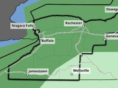
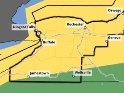
Areas near the Lake Erie shoreline should see cooler temperatures. Meanwhile, the National Weather Service's Storm Prediction Center has most of the region under a marginal severe weather risk for Monday evening and a slight risk of severe storms Tuesday night, as a strong cold front approaches. Jurkowski says gusty winds will be the primary threat both days...
Liz Jurkowski: primary threats
Temperatures will become significantly cooler by Wednesday, with highs in the lower 60s expected.
Severe weather risk for Monday (left) and Tuesday (right). Areas in green indicate a marginal risk, areas in yellow indicate a slight risk. Graphic by the National Weather Service