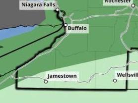
The National Weather Service in Buffalo says a weak cold front from the northwest will bring chances for showers and scattered thunderstorms Thursday afternoon and evening, and some storms could be strong to severe, especially along lake breeze boundaries inland from Lake Erie. Most of Western New York, including the northern half of Chautauqua County, is under a marginal severe weather risk. Forecasters say isolated strong wind gusts will be the primary risk, with localized heavy rainfall also possible. The primary timeframe for severe storms will be 2:00-8:00 PM. There is also under a marginal risk for excessive rainfall across most of the region; any heavier showers and storms may create the potential for flash flooding.
Graphic by the National Weather Service